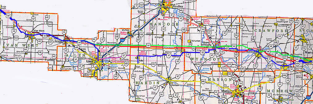
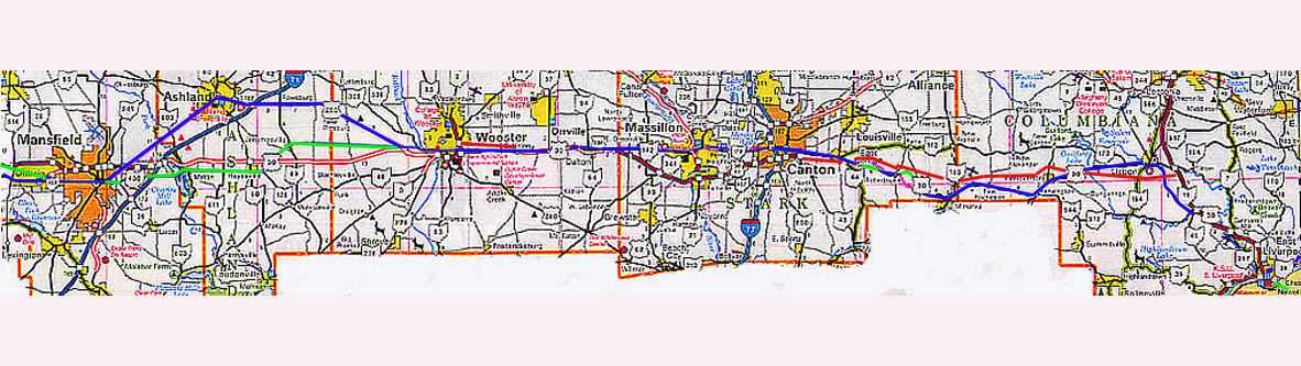
 These maps shows the various routings of US 30 and
the Lincoln Highway in Ohio over the years.
These maps shows the various routings of US 30 and
the Lincoln Highway in Ohio over the years.
The
blue line is the original 1913 routing of the Lincoln Highway
through Ohio
The green line is the second generation
routing (the one that was signed by the concrete markers)
The Red line shows proposed routing for a US 30 expressway/freeway
across Ohio
The Yellow line is for a proposed routing
for the Lincoln Highway from 1911 (it was never implemented)
Photos are grouped as followed:
Western Ohio (Indiana
Border to I-75) | Wyandot & Western
Crawford Counties | Eastern Crawford
County | LH in Galion
Richland & Ashland Counties | Wayne
County | Massillion and Canton
| Eastern Ohio (East Canton to Pa/WVa
borders)
The 1913 LH route
from Upper Sandusky to Lima to Delphos | Steve
Mannix's North Central Ohio US 30 Construction Photos
Links
The Ohio Lincoln
Highway League and Heritage Corridor (The Ohio branch of the
National Lincoln Highway Association)
History
and Road Guide of the Lincoln Highway in Ohio
The online version of Mike Buettner's book on the Lincoln Highway
in Ohio, and used by the authors of this site to help track down
locations to photograph
ODOT US 30 Construction
Page - State page for construction on US 30 from Ada to Upper
Sandusky and Canton to Oh 11
This page created Tuesday, July 17, 2001/Remade on January
25, 2003/Last updated on June 27, 2006
Questions, comments, and submissions can be sent to Sandor
Gulyas or Marc Fannin
Return to Central Ohio Regional Page
| Northeast Ohio Regional Page | Northwest Ohio Regional Page
Sandor Gulyas' Lincoln Highway Photos |
The Ohio Regional Road Pages