I am not affiliated with the Ohio Turnpike Commission Did you find what you needed from this page? Let me know! (Please specify which page) musxf579@hotmail.com Official information may be obtained from the Ohio Turnpike Commission. Please check their site before contacting me. |
    Ohio Turnpike |
| From:
Indiana State Line
To: Pennsylvania State Line |
Contents: Chris Marysz and Marc Fannin
Page maintenance: Marc Fannin ( musxf579@hotmail.com or musxf579@kent.edu )
Graphics and HTML code: Brandon M. Gorte
General format: C.C. Slater
For up-to-date details concerning construction projects, including service area renovation, new interchange construction, and the addition of the third lane from Toledo to Youngstown, see the construction page and the map page on the official Ohio Turnpike website, as well as the "News, Information, & Resolutions" option. For general information, see their official FAQ. State Highway Patrol Turnpike district (District 10) information is located here. The Ohio Revised Code includes "Turnpike Commission" (Title 55, Chapter 5537). Go here on the official site for toll rates. As for an electronic toll collection system being used, not only has it has been considered, new facilities are being built to accomodate it; however, there is no set date for any transponder system implementation (although it might be soon according to this July 3, 2005 story). In the meantime, there has been introduced "Ready Toll" card system, which is described here. See also the official FAQ and this Cleveland Plain Dealer article (Also thanks to Jeff Kitsko and Geoff Hatchard) The Turnpike also began using automatic toll collection machines in 2004 (Cleveland Plain Dealer article, July 20, 2004). Photos of various places along the Turnpike are located here. Other general information may be found at Wikipedia (be sure to double-check sources). The Turnpike just finished a conversion from consecutive exit numbers to mileage-based ones, which started in early 1998 and ended in the days after Labor Day, 2002 (see this page and this press release). I list both on this guide (new numbers first, then old ones). The present-day Turnpike is only the first of five toll highways that were planned by the Ohio Turnpike Commission. For more details, go to this page , and see the 1954 map on this page. Further inactive plans may be found here. More history is and here. The Ohio Turnpike opened on December 1, 1954, from the Pennsylvania line westward to the SR-18 interchange (today part of Exit 218, I-80/I-76/Mahoning CR-18), and on October 1, 1955, from there to just short of the Indiana line. In addition, the origin of the eastern I-76 designation and its predecessor, I-80S, which uses the Turnpike at the eastern end, is discussed on this Federal Highway Administration page. (See also the bottom of this page) Trivia: While the Ohio Turnpike is not an ODOT facility, that organization refers to the Turnpike as I-80K or I-76K (depending on the section) on its straight-line diagrams . Audiocassettes describing the Turnpike are available. Ride With Me: Ohio: I-80, may be purchased here; those produced by Museum of the Open Road are available here. See also Midwest Living Magazine: "Driving I-80 Throught the Midwest: Ohio" Note: This guide does not endorse any business Selected newspapers along the route: Toledo Blade | Sandusky Register | Lorain Morning Journal | Cleveland Plain Dealer (see also this index listing covering Turnpike stories 1985-1999) | Akron Beacon Journal | Youngstown Vindicator (go here for others not listed; for stories on the Turnpike from various sources go here) |
| Eastbound | Westbound | Notes | ||||||
|---|---|---|---|---|---|---|---|---|
Welcome to the Ohio Turnpike |
WEST  Indiana E-W Toll Road Chicago |
|||||||
| Steuben County
Indiana Williams County Ohio |
||||||||
 Edon Edgerton |
TO 
Allen, Mich |
||||||
| EXIT 2 -- MILE 2.7 -- FORMER EXIT 1 WESTGATE TOLL PLAZA EASTBOUND -- GET TICKET WESTBOUND -- PAY TOLL MANUAL LANES ONLY |
||||||||
EXIT 13/2  Bryan Montpelier |
EXIT 13/2 Bryan Montpelier |
 |
||||||
 Tiffin River CLOSEDNEXT PLAZA 28 MILES |
Indian Meadows CLOSEDNEXT PLAZA 32 MILES |
|
||||||
| Williams County Fulton County |
||||||||
EXIT 25/2A  Archbold |
EXIT 25/2A Archbold |
|||||||
EXIT 34/3  Wauseon |
EXIT 34/3 Wauseon |
|||||||
EXIT 39/3B  Delta Lyons |
EXIT 39/3B Delta Lyons |
Maumee State Forest EXIT 39
|
||||||
| Fulton
County Lucas County |
||||||||
Fallen Timbers     NEXT PLAZA 28 MILES |
Oak Openings NEXT PLAZA 28 MILES |
|
||||||
EXIT 52/3A  Toledo Airport Swanton |
EXIT 52/3A Toledo Airport Swanton |
 Toledo Express Airport EXIT 52 |
||||||
EXIT 59/4
Toledo |
EXIT 59/4
Toledo |
Ann Arbor Flint EXIT 59 TO   VIA EAST and VIA EAST andDussel Drive/Salisbury Road |
||||||
| Lucas
County Maumee River Wood County |
||||||||
EXIT 64/4A  Perrysburg Toledo |
EXIT 64/4A
Perrysburg Toledo |
Detroit Dayton EXIT 64 Bowling Green State University
 |
||||||
EXIT 71/5   Stony Ridge Toledo |
EXIT 71/5 Stony Ridge Toledo |
TO NORTH Detroit EXIT 71 |
||||||
| Wood
County Ottawa County |
||||||||
| Ottawa
County Sandusky County |
||||||||
Wyandot NEXT PLAZA 23 MILES |
Blue Heron NEXT PLAZA 28 MILES |
  Mile 76.9 |
||||||
| Sandusky
County Ottawa County |
||||||||
EXIT 81/5A  Elmore Woodville Gibsonburg |
EXIT 81/5A Elmore Woodville Gibsonburg |
|||||||
| Ottawa
County Sandusky County |
||||||||
EXIT 91/6  Fremont Port Clinton |
EXIT 91/6 Fremont Port Clinton |
TO  Bowling Green Sandusky EXIT 91
|
||||||
Commodore Perry NEXT PLAZA 39 MILES |
Erie Islands NEXT PLAZA 23 MILES |
Mile 100.0 |
||||||
| Sandusky
County Erie County |
||||||||
EXIT 110/6A  Attica Sandusky |
EXIT 110/6A Attica Sandusky |
Cedar Point EXIT 110 |
||||||
EXIT 118/7  Norwalk Sandusky |
EXIT 118/7 Norwalk Sandusky |
Cedar Point EXIT 118
|
||||||
| Erie County Lorain County |
||||||||
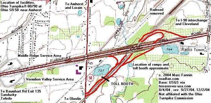
EXIT 135/7A
Vermilion |
EXIT 135/7A
Vermilion |
Oberlin College
EXIT 180
|
||||||
Vermilion Valley NEXT PLAZA 31 MILES |
Middle Ridge NEXT PLAZA 39 MILES |
AND OTHERS Mile 139.5 |
||||||
 Amherst Oberlin |
EXIT 140/7B Amherst Oberlin |
Oberlin College
|
||||||
| WEST |
||||||||
EXIT 142/8A
|
Cleveland West Suburbs Cleveland Erie Pa Buffalo NY NYS Thruway EXIT 142
|
|||||||
| EAST |
||||||||
EXIT 145/8  Lorain Elyria |
EXIT 145/8 Lorain Elyria |
Cascade Park EXIT 145 |
||||||
EXIT 151/9A  EAST
EASTNorth Ridgeville Cleveland |
Cleveland-Hopkins Int'l Airport EXIT 151
|
|||||||
EXIT 152/9  North Olmsted Cleveland |
EXIT 152/9 North Olmsted Cleveland |
|||||||
| Lorain
County Cuyahoga County |
||||||||
EXIT 161/10   Strongsville Cleveland |
EXIT 161/10 Strongsville Cleveland |
Cleveland-Hopkins Int'l Jacobs Field/Gund Arena Cleveland Browns Stadium Rock and Roll Hall of Fame and Museum Great Lakes Science Ctr EXIT 161
| ||||||
Towpath NEXT PLAZA 27 MILES |
Great Lakes NEXT PLAZA 31 MILES |
Mile 170.1 |
||||||
EXIT 173/11   Cleveland Akron |
EXIT 173/11 Cleveland Akron |
Jacobs Field/Gund Arena Cleveland Browns Stadium Rock and Roll Hall of Fame and Museum Great Lakes Science Ctr TO  SOUTH SOUTHEXIT 173
|
||||||
| Cuyahoga County Cuyahoga River Information about the recent bridge rebuild: Turnpike press release 11/3/03 / Timeline WEWS-TV (later video) | WOIO-TV | American Society of Highway Engineers page | Photos on this site Summit County |
||||||||
EXIT 180/12  Akron |
EXIT 180/12
|
TO NORTH
EXIT 180 |
||||||
| Summit
County Portage County |
||||||||
EXIT 187/13  Streetsboro |
EXIT 187/13 Streetsboro |
Cleveland Geauga Lake Park (formerly Six Flags/SeaWorld) Kent State University EXIT 187 |
||||||
EXIT 193/13A  Ravenna |
EXIT 193/13A Ravenna |
Geauga Lake Park (formerly Six Flags/SeaWorld) EXIT 193 |
||||||
Brady's Leap NEXT PLAZA 40 MILES |
Portage NEXT PLAZA 27 MILES |
 Mile 197.0 |
||||||
| Portage
County Trumbull County |
||||||||
EXIT 209/14  Warren |
EXIT 209/14 Warren |
Youngstown-Warren Regional Airport |
||||||
EXIT 215/14A Lordstown |
Ellsworth - Bailey Rd Lordstown GM Plant TO  EXIT 215 |
|||||||
EXIT 216/14B Lordstown |
Hallock - Young Rd Lordstown GM Plant TO EXIT 216 |
|||||||
| Trumbull
County Mahoning County |
||||||||
| WEST |
||||||||
EXIT 218/15
Akron New York City  Mahoning Co Rd 18 Austintown N Jackson Youngstown |
EXIT 218/15
Akron New York City Mahoning Co Rd 18 Austintown N Jackson Youngstown |
Akron FOLLOW WEST
Youngstown New York City FOLLOW EAST |
||||||
| EAST |
||||||||
EXIT 232/16  Youngstown |
EXIT 232/16 Youngstown |
Beaver Creek SP EXIT 232 |
||||||
EXIT 234/16A  NORTH NORTHYoungstown Poland |
Poland Village Park EXIT 234 |
|||||||
Glacier Hills NEXT PLAZA 25 MILES |
Mahoning Valley NEXT PLAZA 40 MILES |
Milepost 237.2 |
||||||
| EXIT 238 -- MILE 238.7 -- FORMER EXIT 17 EASTGATE TOLL PLAZA EASTBOUND -- PAY TOLL WESTBOUND -- GET TICKET MANUAL LANES ONLY |
||||||||
| Mahoning County
Ohio Lawrence County Pennsylvania |
||||||||
EAST
 |
Welcome to the Ohio Turnpike |
|||||||
Ohio Turnpike |
| From:
Pennsylvania State Line
To: Indiana State Line |
This exit guide is not affiliated with the Ohio Turnpike Commission, the Ohio Department of Transportation, nor any other official organization mentioned within. Accuracy attempted but not guaranteed. Note: Some of the links above go to exit lists found at Archive.org and are no longer active. Alternate locations of lists: 1 2 |
Created by Chris Marysz September 22, 1998 (His original version)/Adapted by Marc Fannin Friday, January 7, 2000 (My original version)/Revamped April 28, 2000/Last revised February 16, 2006 (note added September 2, 2009)
Return to The Western Reserve Exit Guide Page