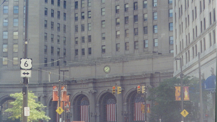
Public Square is the very center of Cleveland. Many events which are part of city festivities are held here. On its south corner is Terminal Tower, for many years the tallest building in the city, and currently the structure above a popular shopping center (Tower City Center).
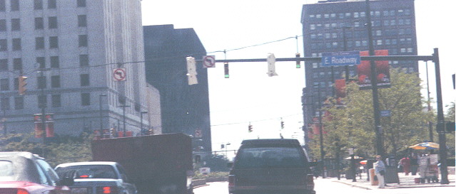
This is looking southeast across Superior Avenue (notice US 20 and US 42 are not mentioned).
Public Square is located around the intersection of Superior Avenue and Ontario Street. A street runs around its periphery, always paralleling one of those two streets. Many highway routes converge there. US 6 runs southwest-to-northeast on Superior Avenue. US 20 enters with US 6 and US 42 from the southwest, but leaves on its own following Euclid Avenue, which branches to the east off of the periphery street (and may be reconstructed soon). (Euclid used to carry Alternate US 6/Alternate US 20, with mainline US 20 following US 6/Superior. Euclid Avenue: Cleveland's Sophisticated Lady [Karberg/Toman, Cleveland Landmarks Press Inc., ISBN 0936760192] has a photo of Alt 6/Alt 20/US 322 shields from 1940 on page 65, as well as other historic photos.) US 422, Ohio 8, and Ohio 14 also start at the square and leave together on Ontario Street southeastbound from Superior. Although it would seem that US 42 and US 322 would both originate there, both those routes actually start one intersection to the northeast on Superior (see the "Old to new" entry below in this section). The following map has added in where the various routes end/begin and which streets they follow.
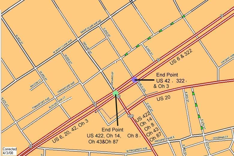
(Note about the map: SR-3 and SR-43 are NOT signed at Public Square, even though the Ohio Department of Transportation's Straight Line Diagrams show them ending there. SR-87 was also formerly without markers in downtown until a route marker installation project in mid-2007.)
Identifying most of these routes are unique sign assemblies.
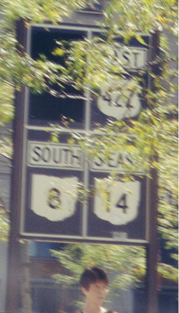
This is just southeast of the Superior/Ontario intersection within the Square. Notice the blacked-out panel. The black is covering up a US 21 shield (US 21 did run with the other routes until the early 1970's). What is surprising is that the black cover was not applied until late 1998 at the earliest! (There was also a US 21/422/SR 8/14 assembly southbound just south of Public Square until around then - The Heart of Cleveland: The Story of Public Square in the 20th Century [Deegan/Toman, Cleveland Landmarks Press Inc., ISBN 0936760125] has a photo of this from the 1970s or so on page 119, as well as other historic photos. This assembly was replaced with modern shields minus the US 21 shield.) Also note the "S-EAST" label for Ohio 14. Ohio used to regularly label its predominantly diagonal highways with diagonal directions.
This is one of two consecutive sets on eastbound Superior at Ontario. The Ohio Turnpike is about 15 miles away at ths point, and is mentioned almost nowhere else in the downtown area.
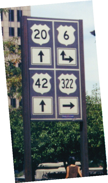
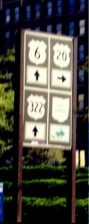
This is northbound on the east periphery street at Superior. Drivers are directed straight (then around the periphery) to get to US 6, 20, and 42 due to a left turn restriction, one of many throughout the Square.
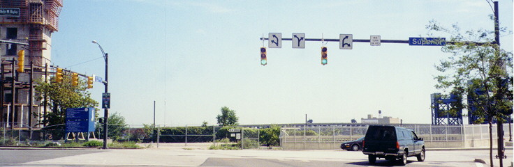
The City of Cleveland started a mass upgrading of traffic signals towards the end of 1999. You can see both types of set-ups here at the intersection of Superior and the east leg of the periphery street. This is the intersection where US 42 and US 322 start (US 42 goes ahead, US 322 goes behind) -- as strange as that may seem, it is confirmed by the Ohio Department of Transportation's Straight Line Diagrams (use this link to jump to the ones for Cuyahoga County). The Superior/Ontario intersection is just beyond.
At least two other Northeast Ohio communities also have a "Public Square", Medina and Streetsboro.
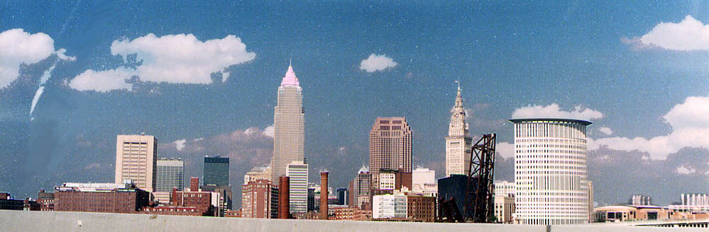
The Cleveland skyline from the top of the Main Ave Bridge, looking east. (Photo taken in June, 2004)
This is Sandor's favorite sign assembly in Cleveland. ;) Whoever installed this lane-use sign assembly had to get creative. This is at the south end of West 9th Street where it meets Superior Avenue (easy left and sharp right), Huron Road (easy left), and the Veterans Memorial Bridge (see below) (easy right). Fortunately Superior to the right is one way away from the intersection. (It leads into the Flats district, the entertainment district, formerly an industrial district, located in the Cuyahoga River flats -- if that section were two-way, the exiting Flats traffic would make negotiating the intersection much more difficult.) The sign on the far traffic light pole directs traffic down Huron to I-71, I-77, and I-90. (Note, 6/22/02: The building under construction on the left is the new federal courthouse.)
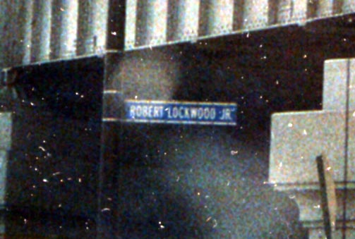
Sandor's new favorite Cleveland streetsign. Robert Lockwood
Jr is a famous blues guitarist (last living connection to Robert
Johnson) and has called Cleveland home since 1960
(Sidenote,
in a 1995 interview with Living Blues Magazine, Lockwood said
that Sunny Boy Williamson [Alick "Rice" Miller] talked
Lockwood into staying with him, work and collect some money and
then head off to New York City. Lockwood hasn't changed his home
address since, while Sonny Boy got wanderlust and moved on again.
More about Sonny Boy, and the blues, can be found on my
Mississippi Delta pages)
The city named 10th
St, between River and Canal Rds, in the Flats, after Lockwood
in 2001. The sign photographed is at the intersection with Canal,
Carter, and Center Rds, just SW of the Detroit-Superior Viaduct.
(Photo taken in June, 2004)
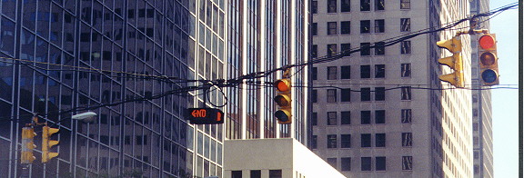
The "NO" device in the middle of the traffic light assembly is a neon left turn restriction sign, illuminated only during certain times like rush periods. They are found all over Cuyahoga County, but I have never seen one outside the county. As Cleveland upgrades its traffic lights, these will begin to disappear, replaced with more contemporary electronic turn restriction signs (see below). (Note: The signals at this intersection did get replaced sometime in 2000.) On East 9th Street southbound at Superior Avenue
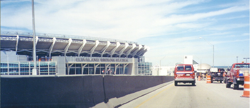
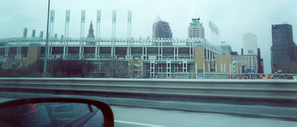
Descending from the Main Avenue Bridge (see below) eastbound on the Cleveland Memorial Shoreway (Ohio 2 at this point), one may see three of Cleveland's newest attractions. In the foreground is obviously the new Cleveland Browns Stadium, home to the National Football League team of the same name. At the time this picture was taken, the letters had just been installed, and the new Browns had yet to play their first regular-season game. Directly ahead is the Great Lakes Science Center (building with dome) and behind it is the Rock and Roll Hall of Fame and Museum, usually just called "the Rock Hall" (tall structure). Lake Erie is visible on the right (all three attractions lie just onshore).
Because the entrance to the eastbound Shoreway from West 3rd Street is so close to the Shoreway's exit to East 9th Street, a supplemental ramp was built connecting the two ramps in order to reduce weaving on the Shoreway. An entrance to the Amtrak railroad station is located off of this slip ramp, making it interesting for traffic that needs to access it. Fortunately there is a back entrance which Shoreway Westbound travellers can access by using a flyover to the Cleveland Municipal Parking Lot about a half-mile to the east so they don't have to do any backtracking at West 3rd/East 9th. The sign in the background of the picture includes an Interstate 90 shield even though Ohio 2 has yet to reach I-90. Other area signs include highways which are not there, including the signs for I-90 Eastbound which include "SOUTH {I-271}" at and approaching the I-90/Ohio 2 split in Euclid, and ones around Dead Man's Curve (see below). Cleveland Browns Stadium is immediately to the left in the picture. Note: East 9th Street's honorary name is Rock & Roll Boulevard as of Summer 2003 (see this Plain Dealer article from June 28, 2003).
On August 8, 2003, a westward extension from the ramps between West 3rd and Ohio 2/Shoreway to the east to the Port of Cleveland opened. These ramps are an extension of the original ones, underpassing West 3rd (connections from Ohio 2/Shoreway to West 3rd are retained via new auxiliary ramps). See this Plain Dealer article from August 8, 2003. Photo, inside Northeast Ohio Areawide Coordinating Agency Fall 2003 newsletter | Aerial photo of original configuration
A sign assembly displaying all three mainline Interstates which run in Cleveland. (I-80 misses by quite a bit.) This is in the middle of the interchange complex south of downtown officially known as the "Central Interchange"; go here for a map. Immediately to the right just off the picture is the ballpark of the Cleveland Indians Major League Baseball team, Jacobs Field (part of the Gateway Sports and Entertainment Complex, which also includes Gund Arena, home of the National Basketball Association team the Cleveland Cavaliers).
Wider shot, showing Jacobs Field and surrounding buildings
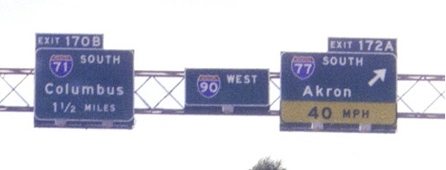
End signage on I-77 Northbound approaching I-90
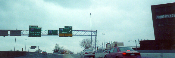
I-90 Eastbound at I-77
Also see I-77 by AARoadtrips.
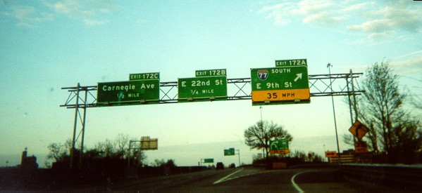
East 9th Street NB from Interstate 90
East 9th Street is a large thoroughfare in downtown Cleveland. It connects to both I-90 (the Innerbelt) and Ohio 2 (Cleveland Memorial Shoreway) as well as to the lakefront attractions. Note the Variable Message Signs over the street. Jacobs Field is to the left.
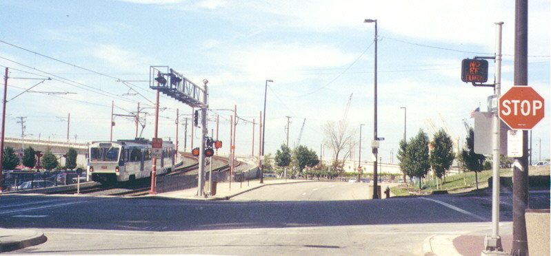
In 1996 the Greater Cleveland Regional Transit Authority constructed its Rapid Transit train Waterfront Line to the Flats in connection with Cleveland's Bicentennial. There had been so many abandoned industrial railroad spurs through there that the RTA had to place "ACTIVE TRACKS" signs under the crossing signals for the new line (they have since been taken down). As you can see, electronic "NO LEFT TURN" signs are activated on West 10th Street when a train crosses Main Avenue on its way into the Flats East Bank station. This is directly under the Main Avenue Bridge on the Shoreway/Ohio 2 (see the bridges page); its shadow is covering Main Avenue. Lake Erie is immediately ahead (not visible).
Entrance to Edgewater Park
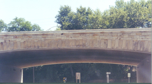
The West Shoreway displays many features which have existed since it was opened more than a half-century ago. One of them is this original overpass at the entrance to the popular Edgewater Park, part of Cleveland Lakefront State Park. This interchange used to be a trumpet (see Kurumi's Field Guide to Interchanges), but in the 1980's the loop ramp from the eastbound Shoreway was turned into a direct ramp (before/after). Interestingly, the US 6/US 20/Ohio 2 reassurance sign assembly heading east away from this interchange is in the style of the state of Washington, with the markers on a green guide sign, rather than in a free-standing configuration conventional in Ohio and most other places.
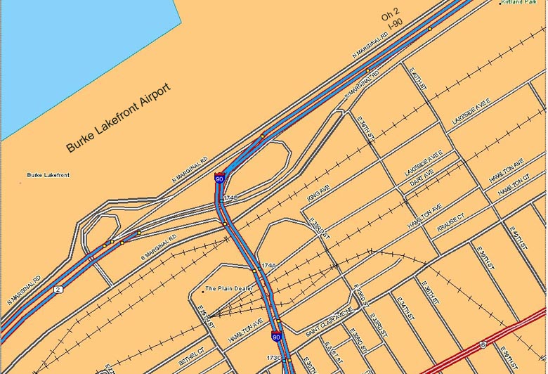
"Dead Man's Curve", officially known as the "Innerbelt Curve", is a sharp curve on Interstate 90 within its unusually-oriented trumpet interchange with Ohio 2 just northeast of downtown Cleveland. (Map | Aerial photo) Because the curves are so sharp, extra warning devices are needed to alert traffic of the unexpected conditions. These photos were taken approaching from the east on I-90/Ohio 2 Westbound.
At the Curve
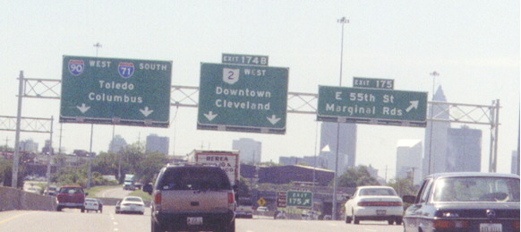
The chevron arrows flash in sequence in the direction of the traffic (there is a fourth one to the left not pictured). Often these are decimated by drivers not making the turn completely. On October 14, 2004, new posts had been constructed near the existing flashing arrow signs, presumedly to accomodate new arrow signs with LED flashers. Rumble strips are set into the pavement of the left two of the four lanes (those for I-90 traffic) approaching the Curve; the last two sets are visible at the bottom of the picture. I don't know which is stranger, slowing down to go over them while traffic on the adjacent two Ohio 2 lanes travels unimpeded (they need no strips because Ohio 2's path is dead straight), or travelling on the Ohio 2 lanes and hearing cars right next to you going over rumble strips! I-71 is identified on the sign even though it does not begin until the other side of the downtown area. Note Cleveland Browns Stadium in the background on the right; the Science Center and the Rock Hall are in front of the Stadium, off the edge of the picture.
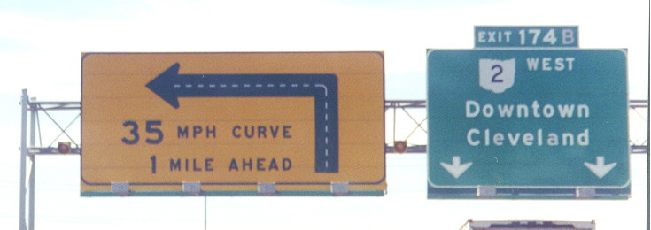
One mile east
The yellow lights flash simultaneously. By October 14, 2004, they had been converted to LEDs.
About one-and-a-half miles east
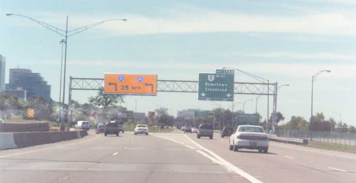
Note I-71 on the sign again. The brown sign behind the "EXIT 175" gore sign lists the Science Center and the Rock Hall as Exit 174B destinations. The East 55th Street overpass in the distance has two "REDUCED SPEED AHEAD" signs attached to it (one may be seen just to the left of the white car); the actual speed limit through Dead Man's Curve is 50 MPH (35 MPH is an advisory speed).
Dead Man's Curve Links
ODOT's Cleveland Innerbelt Study
Plain Dealer Lakefront Development Study
Connecting Cleveland: The Lakefront Plan (Cleveland City Planning Commission)
Deadman Curve & Public Square maps were from DeLormes Maps
Page created on December 25, 2002/Last updated on July 9, 2007
Questions and comments about this page can be sent to Sandor Gulyas or Marc Fannin
Return to Cleveland Virtual Roadtrip