The routes in and around South Bend, Mishawaka, and Elkhart, Indiana have been in disarray since the St. Joseph Valley Parkway freeway was completed from US-31/Michigan Street south of South Bend eastward to east of Elkhart. This page is designed as a source to keep track of everything. Photos and more information
The St. Joseph Valley Parkway: The South Bend/Mishawaka/Elkhart Bypass. This continues north to Napier Avenue east of Benton Harbor, Michigan, and will eventually connect to Interstate 196 or the nearby Business Loop 94 interchange at Interstate 94 . Contrary to its name, it is simply a freeway. It is designated US 31 from Michigan to the US 20/Lincolnway West interchange, then US 20 and US 31 to the US 31/Michigan Avenue interchange, then US 20 until the end of the freeway east of Elkhart. A rough timeline:
US 6: An east-west highway south of South Bend/Mishawaka/Elkhart. Ironically, an Indiana 6 ran in nearly the same location prior to the extension of US 6 west of Erie, Pennsylvania in the 1930's. The Bremen bypass section was built in the 1980's (the old route through town became Indiana 106). See also this page.
US 12: Runs along Lake Michigan, going through downtown Michigan City. See also this page.
US 20: This now runs on the St. Joseph Valley Parkway from near the South Bend Regional Airport all the way to the eastern end of the Parkway east of Elkhart. Business US 20 is posted in St. Joseph County along the old route (signs posted outside of South Bend and Mishawaka lack the "BUSINESS" indication), but no designation is posted along the route in Elkhart County -- see this INDOT news release for information regarding the St. Joseph County portion. The portion of Bus. 20 at and just east of the St. Joseph Valley Parkway (part of Lincoln Way West) will be shifted south beginning in 2005 as part of the South Bend Regional Airport expansion. As of July 2002 street signs in unincorporated eastern St. Joseph County read "US 20" while those in unincorporated western Elkhart County read "OLD US 20". US 20 was once signed along Indiana 2 west of South Bend and Indiana 933/old US 33 between South Bend and Elkhart.
US 31: US 31 runs along the St. Joseph Valley Parkway from south of South Bend into Michigan. A Business US 31 (created 1982) runs along Main and Michigan Streets (former US 31) and Cleveland Road. US 31 is planned to be upgraded and relocated south of US 20/St. Joseph Valley Parkway (South Bend to Plymouth study | South Bend to Indianapolis information).
US-33: US-33 ends at US 20 southeast of Elkhart. (Note: While the INDOT Interchange Book shows US-33 running from that point with US-20 then US-20/31 then US-31 to the Michigan state line, INDOT's Reference Post Manual - see bottom of this page - as well as posted signage indicate that US-33 does in fact end at US-20.) From there northwestward there is no designation along the old route (for the most part Lusher Avenue and Lincolnway East) until St. Joseph County, where it becomes Indiana 933. Indiana 933 continues to Michigan where it becomes M-51. US-33 was Indiana 2 from South Bend to the Ohio line until the 1930's.
In late 2004 INDOT proposed removing Indiana 933 (WNDU-TV article, 11/19/04).
US 35: Formerly Indiana 29 (1920's-1930's). For a while until the 1980's it ended at the Interstate 94/US 20 interchange southeast of Michigan City when it was extended to US 12. It has been proposed to be truncated at the US 20/Indiana 212 interchange (Michigan City News-Dispatch, 12/7/04).
US 112/US 112S: US 112 used to run along present Indiana 19 southward from Michigan, then old Indiana 19 into Elkhart, then southwestward to old US 33/Indiana 933, then along that route to South Bend, then along Indiana 2 to US 20. Briefly it seems that it was to be renamed US 112S and extended westward, but there is only record of that designation for one year (1934) and it didn't go past Indiana 29 (now US 35) in LaPorte. By 1935 US 112 ended at US 20 west of Elkhart after being rerouted onto the Elkhart northwest bypass (primarily Bristol and Nappanee Streets), and by 1937 it had been rerouted again to stay in Michigan (it eventually became a part of current US 12). See also this page.
US 131: Highway with very short segment in Indiana, running 0.67 miles between Michigan and the Indiana Toll Road. Officially paired with the northernmost end of Indiana 13, although no signs for Indiana 13 are posted along this stretch, and in fact Indiana 13 is indicated in the field as ending at the Toll Road from the other direction (see this INDOT .pdf file and these photographs). It used to end at US 12 in Michigan, but was extended to the Toll Road after the Toll Road opened. Originally ran along M-103 (Indiana 15's counterpart) and ended at the Michigan/Indiana state line.
US 421: Formerly Indiana 43 (1920's-1930's). Until the 1980's it continued past US 20 to US 12 in downtown Michigan City.
Indiana 2: Used to run to Ohio before being replaced in part by US 33 in the 1930's, then ended in downtown South Bend, the last routing being Western Avenue to Chapin Street, ending at Indiana 23. Indiana 2 now ends at the St. Joseph Valley Parkway/US 20/US 31.
Indiana 4: Exists in three segments along the same latitude. The westernmost segment runs between Indiana 2 in LaPorte and US 31 (first proposed 1935); the middle one runs from Goshen to Indiana 13.
Indiana 13: North-south highway in eastern Elkhart County which ends according to signage at the Indiana Toll Road at US 131's southern end but officially continues "hidden" with US 131 to the Michigan/Indiana state line (where US 131 continues northward) - see this INDOT .pdf file and these photographs. Became M-103 in Michigan when US 131 followed present-day M-103 (1920's-1930's).
Indiana 15: North-south highway in central Elkhart County traversing Goshen. Becomes M-103 in Michigan.
Elkhart County Road 17: North-south road in central Elkhart County traversing Goshen. This road is undergoing improvements to become a main artery between US 6 and US 12 just into Michigan. Ground breaking took place in early 2002 to extend the road the last few miles to US 12. CR 17 links the Indiana Toll Road (I-80/90) at Exit 96 to the eastern end of the St. Joseph Valley Parkway (US 20 at that point). This link is not planned to become freeway. Indiana 120 was officially rerouted onto part of this section of CR 17 (see the Indiana 120 entry below). The section in Michigan is M-217 (South Bend Tribune, July 17, 2002; go here for information and a map, here for photos, and also see this page). M-217 opened in mid-August 2002. The rest of CR 17 was slated to open September 25, 2002, at 12:00 PM EDT, and did open as planned. The CR 17/M-217 route is dubbed the "Michiana Parkway". With M-217 being assumed by the Michigan Department of Transportation, M-205 was removed in late November 2002 to compensate so that net mileage of state-maintained highway would remain largely unchanged. In January 2003 this project won the Graham Woodhouse Intergovernmental Effort Award given by the Southwestern Michigan Commission metropolitan planning organization.
Indiana 19: As late as 1998, this ran through downtown Elkhart. It has now taken over the route of old Truck Indiana 19 (Bristol and Nappanee Streets). Became M-205 in Michigan until that route was removed in late November 2002 in conjunction with the creation of M-217 (info). Part north of Bristol Street was once US 112.
Indiana 23: This route has remained essentially unchanged since being rerouted to the east and south of downtown South Bend in the 1960s. (That reroute involves streets planned to have been part of a mostly-cancelled plan for an "inner belt" involving Madison, Marion, Eddy, Sample, and Chapin Streets.) Becomes M-62 in Michigan.
Indiana 29: Former designation for US 35.
Indiana 39: North-south route traversing LaPorte and LaPorte County. Becomes M-239 in Michigan.
Indiana 43: Former designation for US 421.
Indiana 104: Connects Indiana 4 east of LaPorte to Walkerton (US 6 and Indiana 23).
Indiana 106: Former route of US 6 in Bremen.
Indiana 112: Once a part of the old US 112, this route was a northwest bypass of Elkhart, running along Bristol and Nappanee Streets from Indiana 19 (Cassopolis Street) to US 20. The majority of it was taken over by Indiana 19 with the short westernmost segment (between old US 20 and Nappanee Street north of Lexington Avenue) becoming unnumbered and renamed By Pass Road.
Indiana 119: Connects Indiana 19 to Goshen.
Indiana 120: Until September 11, 2000, will run westward into Elkhart, ending at old US-20 (and therefore disconnected from the state highway system on its west end). After September 11, 2000, will turn south onto Elkhart County Road 17 and end at the US 20/CR 17/old US-20 (Toledo Road) interchange complex (see this INDOT press release and this article), similar to the route it took before going into Elkhart. As of April 26, 2003, signage had not been changed yet.
Indiana 123: Designation from 1937 until 1980's along Mayflower Road between Business US 20/Lincolnway West and Indiana 23.
Indiana 133: Extension of former US 33 in Elkhart along Main Street from Lusher Avenue to downtown. Source 1 | Source 2
Indiana 212: Eastern part of Michigan City bypass, connecting US 20 and US 35 to US 12.
Indiana 219: This used to run along the St. Joseph/Elkhart county line from former US 33 to former US 20. The road was turned over to St. Joseph County on May 21, 1999 -- see this INDOT news release.
Indiana 220: No longer extant, it was originally planned to run from New Carlisle and US 20 northeastward to Michigan where it would connect with an extended M-40, but was later created to follow a short loop of the old Lincoln Highway from US 20 through Rolling Prairie and back to US 20 (it probably once was a portion of US 20 itself).
Indiana 223: Designation from 1937 until the 1980's along Crumstown Highway between old Indiana 123 and Indiana 23 south of Crumstown.
Indiana 319: Former designation for what was the western end of Indiana 120 until 2000.
Indiana 331: This route used to run into downtown Mishawaka from the south, then continue north to its end at US 20 (intersection of McKinley Avenue and Main Street). It has moved to the east. Here are the details on Indiana 331 as reported in a message by Chris Marysz posted to Usenet's misc.transport.road group on May 19, 1999:
"Indiana 331, which ends at Old US 20 in Mishawaka will soon end at IN 23 north of the Indiana Toll Road (I 80/90) Exit 83 interchange. The Indiana Toll Road built this interchange to connect with the Capital Avenue Freeway. At this time, Capital Ave. near the interchange was only a two lane connector road to IN 23. Now it's 4 lanes between there. NIMBYists fought long and hard over about this project. The path of the project will destroy homes. In 1996, twin bridges were erected over the Indiana Toll Road to one street south, Cleveland Rd. In late 1997, early 1998, the road was extended one mile south to Douglas Road, and ends there now. There is another section of Capital Ave, 3 miles south of Douglas Road. Most of Capital Ave in the southern section is two lanes, except for the 4 lane section north of IN 933, Old US 33 [this part crosses the St. Joseph River and ends at Jefferson Blvd.]. That section was built in 1987. As soon as this 3 mile section is built, there will be sort of an eastern bypass of Mishawaka. All of this will be designated as IN 331." View message in Google groupsThe portion south from Douglas Road to Day Road was open by 2003. Construction on the portion from Day Road to Jefferson Boulevard started June 30, 2004 , with the Day-to-McKinley Highway (old US 20) stretch opening December 9, 2004, and the McKinley-to-Jefferson stretch planned to open late-Spring/early-Summer 2005. The portion of existing road from Indiana 933 south to US 20/St. Joseph Valley Parkway, as well as a rebuild of the St. Joseph River bridge, should start upgrade reconstruction in 2006. (WNDU-TV articles: 1/23/04, with map | 2/11/04 | 5/28/04 | 6/30/04, groundbreaking | 11/4/04, with meeting handout transcription | 11/5/04 | WSJV-TV article: c.12/9/04 ) Although the 331 designation was applied to the completed portions of Capital Avenue in the late 1990s, identification from the Toll Road I-80/90 did not exist until 2005.
Gary Fisk, P.E. provides this .doc copy of past and future plans for Capital Avenue . See also this INDOT press release , the City of Mishawaka Public Works department page , and the Capital Avenue plan on the St. Joseph County Area Plan Commission "Comprehensive Plans" page .
Indiana 520: Very short connector between US 12 and US 20 in Town of Pines west of Michigan City.
Indiana 933: See US 33 above
Indiana Toll Road/I-80/I-90: This highway has remained virtually unchanged since it opened in 1956; however, its interchanges and their numbers have changed. The Notre Dame exit in Roseland (currently Indiana 933/Business US 31) was originally Exit 6, then was renamed Exit 8 due to two new interchanges to the west, and is now Exit 77 (number based on mileage). Exit 77's ramps used to connect to 933/Bus. 31 with an interchange, but with the removal of a railroad track c. 1984 that the ramps used to cross on an overpass, the interchange was converted to a T-intersection between April 18 and May 8, 1995, when it opened. Exit 72 (St. Joseph Valley Parkway/US 31), Exit 83 (Mishawaka, new Indiana 331), and Exit 101 (Indiana 15) were added in the early 1980's, and Exit 96 (Elkhart East, County Road 17) was built between July 16, 1996 and early 1997 when it opened. The ramps connecting Exit 72's ramps to Nimtz Parkway (old Cleveland Road) were added in 1993. For more on the Toll Road, follow these links: Exit guide / Exit map (.pdf) / Exit diagrams / Services map (.pdf - large) / Trivia / History / Toll rates / Construction / District page / More official information (at bottom)
Interstate 94: Main highway from Chicago to Detroit and Grand Rapids. It was not completed into Michigan until the early-1970's.
The Lincoln Highway: The Lincoln Highway runs along US 30 in Indiana. However, its original route runs further north, through South Bend, Mishawaka, and Elkhart. That route uses these highways:
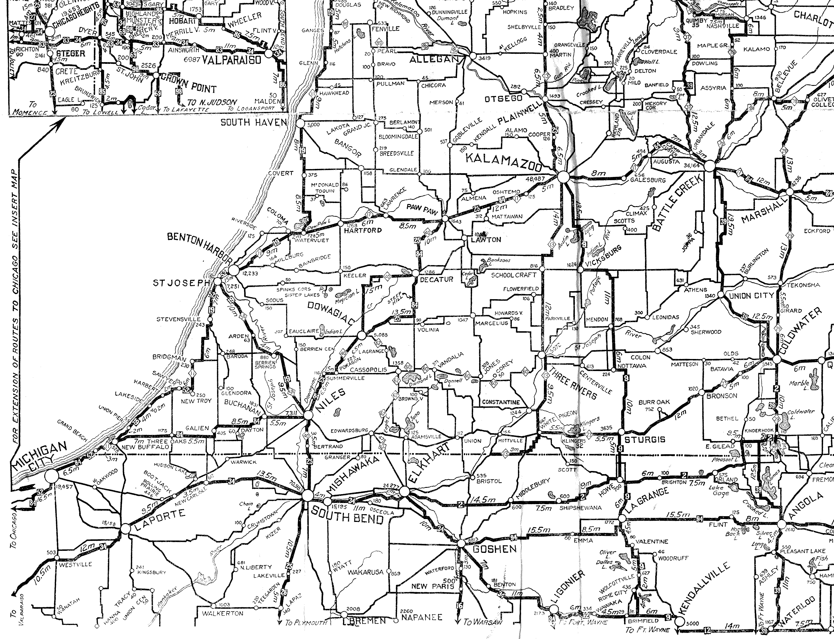
South Bend/Mishawaka/Elkhart inset from the official Indiana state map Requires Adobe's Acrobat Reader
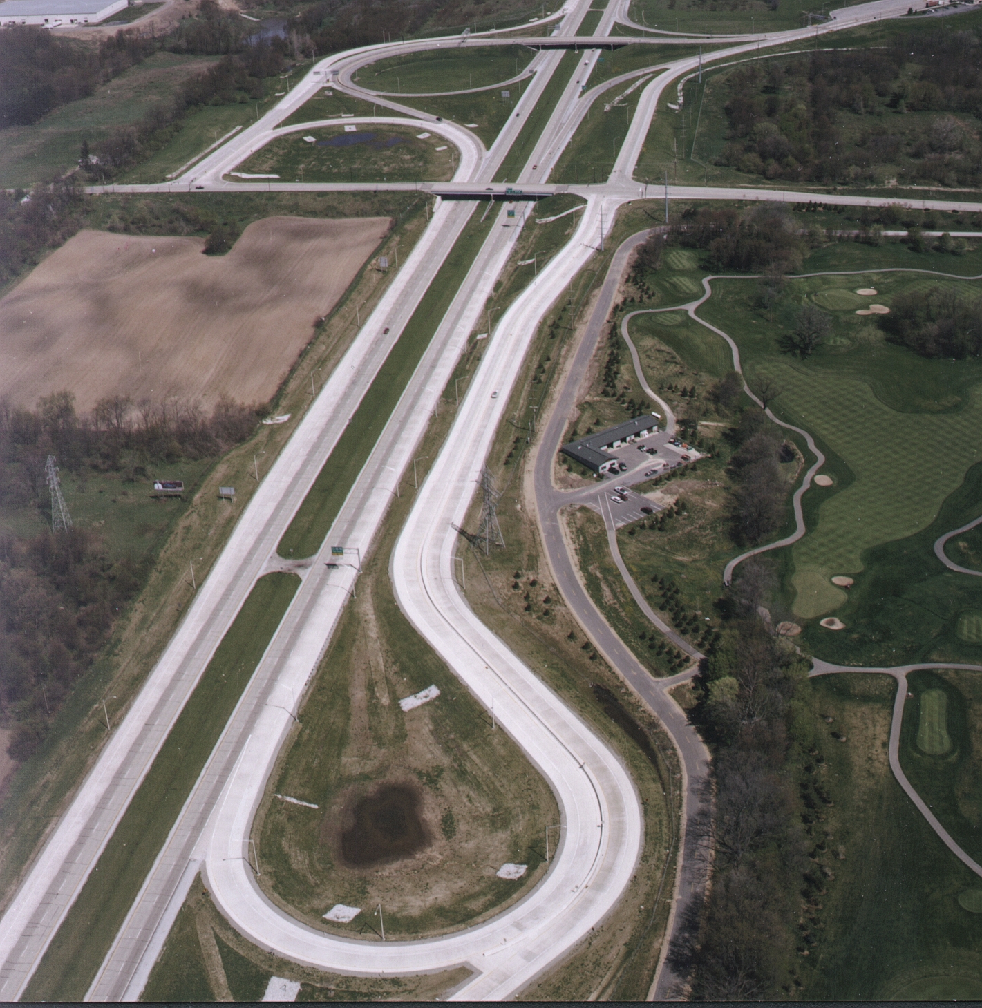
This map reflects everything listed above except the business routes (business routes in Indiana are not state-maintained), portions of new Indiana 331, and the ramps from Nimtz Parkway to US 31 and the Toll Road (.pdf diagram | aerial photo | overhead photo [1.5 MB], contributed by P.E. Gary Fisk/DLZ).
Michigan City inset from the official Indiana state map Requires Adobe's Acrobat Reader
LaPorte County from the official Indiana state map
St. Joseph County from the official Indiana state map
Elkhart County from the official Indiana state map
Links to the rest of the official state map: 2002 map (large) | Counties | City insets
For more on routings see the Reference Post Manual entries (all .pdf files - User's guide/introduction .pdf) for the Laporte District and the Fort Wayne District. Index of all entries (scroll down to "Manuals") | See also the INDOT Interchange Book
Realtor Barb Campbell has information on Elkhart County, including the county road system, here.
For information on routes in other parts of Indiana, go to Indiana Highway Ends by Charles Sarjeant.
Thanks to Stephen Summers for some of the historical information, culled from official Indiana road maps. See also this 1921 map excerpt (scan by Chris Bessert).
This page created Tuesday, March 14, 2000/Last revised July 20, 2005
Return to Marc Fannin's Michiana Roads