
Note: This page was written by Brian Polidoro. His website
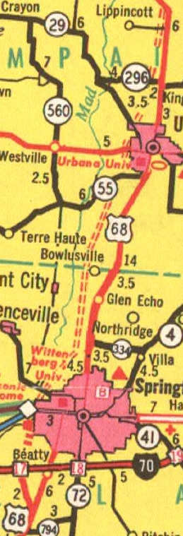
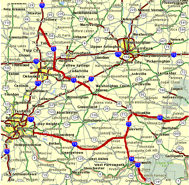
The US 68 freeway was originally supposed to bypass Urbana as well as Springfield as shown above (1969). The reason, as I have heard, that the freeway was not finished is Champaign County and/or Urbana did not want the freeway. But this freeway has been reborn. According to ODOT's 2001-2005 projects list, an environmental study is being done for a bypass of Urbana.
["As I understand it, the freeway was halted due to Cedar Bog, which is about 1 mile into Champaign County directly North of where the Frewway ended. Recently the freeway end was tied more directly into 2 lane existing US 68, instead of exiting the half-finished interchange and travelling along County Line Road..." -- "Mr Sparkle" -- added by MGF]
The proposed US 68 freeway was not shown at all on the 1971 Ohio map. The only part that was shown was the completed section from I-70 to US 40/OH 4. Then in the 1972 Ohio map, US 68 is shown as it is today.
ODOT has made available online old road maps. They can be found here. And thanks to those maps I have put together this timeline for the evolution of the highway.
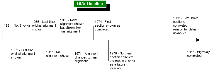
Most evidence suggests that the reason the alignment was changed was to accomodate Wright-Patterson Air-Force Base. It's too bad they couldn't build both alignments which is what I would have done. The original aligment would become I-675. And the other alignment would become I-870.
This is the first time I-675 is shown on a Ohio map.
This is the last time I-675's original alignment is shown.
The 1967 map is just like the 1965 map except I-675 has been removed.
This is the only time this odd alignment is shown. I-675 is proposed to go further east. I'd suspect is was going to replace Fairfield Road.
This is the first time the final alignment of I-675 is shown.
This shows the first section completed from OH 235 to current exit 16.
By '76 the northern section was completed connecting WPAFB to I-70.
Between 1976 and 1985 the status of I-675 does not change. The reason for delay is unknown but my guess is it wasn't top priority so it had to wait for funding. The airforce base had access to I-75 via OH 4. [A. Adams, area resident, writes: "One group was opposed to it because they felt it would hurt downtown. Another group was in favor of it because they felt it would help the eastern side of the area grow. When Dayton finally decided in favor of the highway, the Carter administration initially denied funding for it, and later offered to finish the road as a two lane highway. Dayton wanted 3 lanes, and for whatever reason the Reagan administration agreed and funded the project." -- MGF]
I-675 is finally shown as complete by 1987. 35 years after it first was proposed.
The other reason I think the original alignment wasn't built is the Mad River area jus north of the airforce base is wetlands which could be a problem, or the ever popular NIMBY answer.
["The main reason I-675 was delayed so long is that when it finally came up for funding when NEPA was passed...Constantly changing mandates and the State's learning and relearning the new laws....In fact I think it was one of the very first (if not first) EIS required for a roadway project under NEPA" -- "Mr Sparkle" -- added by MGF]
I have expanded my proposal for Ohio to include I-68, I-73, and I-74. First I will present my routing for I-68 in Ohio and West Virginia. [I-68 link -- MGF] Starting in central Ohio, I-68 begin in Chillicothe. At the end of the limited access highway in Chillicothe a new highway would be built following US 50 to the West Virginia border. I-68 would cross the Ohio either north or south of Parkersburg. This would be determined by the most plausible route. I-68 would bypass Parkersburg and then cross I-77 then join the current US 50 highway in WV. This highway would then have to be upgraded to limited access to I-79. It already is limited access through Clarksburg. Then I-68 would follow I-79 to Morgantown where the current end of I-68 is located. I believe this would work because a majority of the route is already at least a highway if not limited access. This also would help the development of southeast Ohio which I hear from an OU acquaintance is the poorest part of Ohio.
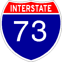
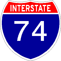
[I-73/74 link -- MGF] I-73 would spur off of I-75 north of I-70, where exactly I'm not sure would be the best. But it would end up at the northern end of I-675. This would convientiently solve the bypass problem in Dayton by completing the eastern bypass. I-73 would supersede I-675 until it leaves current I-675 and turns to the east and pass Xenia to the north. I-73 would join up with the US35 freeway east of Xenia and follow it to Chillicothe. US35 would be cosigned with I-73. Then I-73 would meet the end of I-68 and turn south towards Portsmouth. I-73 would be cosigned and follow US23. Then I-73 would meet I-74 south of Waverly. I-73/I-74 would then follow the proposed I-73/I-74 corridor, bypassing Portsmouth etc. I-74 would be an upgraded OH 32.
Being ODOT doesn't want to build new interstates, I had these follow current highways where possible. Thus not requiring much new highways, mostly upgraded highways and some town bypasses. Also some of the proposed I-70/I-75 interchange improvements would not be necessary due to the new highway.
A possible twist to this proposal would be to re-route I-75 onto 675 and the new highway, and the former 75 would be a x75 maybe 675. This way through traffic would follow I-75 around Dayton instead of through it. I-73 would then end at I-75 in Fairfield.
I-68 Alternatives:
An alternative is use the same route from Morgantown to Athens OH then upgrade the US 33 highway from Athens to Columbus. This would most likely necessitate a bypass of Lancaster.
The most direct route would be the shortest route but there is no current corridor there and the mountainous terrain would deter making a new corridor. This route would go from Morgantown to Cambridge OH.
And for those believers that I-74 should not be below I-70: At Chillicothe I-68 could multiplex with I-73 and head south then follow the proposed I-74 above to Cincinnati. And maybe extend I-68 to Indy.

As part of TEA-21, a feasibility study is scheduled for US 22 in Ohio for inclusion as part of the Interstate System [see Item OH027 on this list -- MGF]. I'm not sure which parts in Ohio are being studied but the part that makes the most sense is the part east of I-77. I think this would be a good idea to give a better route to Pittsburgh for people traveling east on I-70. I think this route could become an even or an odd x77 or x70 interstate depending on where the two ends of the interstate are located. If the interstate ends at the junction of PA 60, which is what I think it should, it will be an odd 3di. This is because it doesn't look likely that PA 60 will become an interstate. A 2di interstate like I-72 should only be used if the designation can reach Pittsburgh.
Transferred to roadfan.com (Marc Fannin/Sandor Gulyas) Saturday, June 15, 2002/Minor updates June 20 and 21, 2002 and May 21, 2004
Comments to Marc at musxf579@kent.edu
Return to
Southeast Ohio Roads
or
Southwest Ohio Roads