The maps
maps
Louisiana
has folklore concerning its music, its food, its people, its politicians,
and its geography. So why not its roads.
There
are several people who have already written about the I-410 proposal,
so I will direct you to their work:
However, none of them have any visual material showing
the proposed route. So this is where I step in.
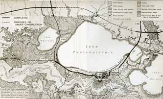 Regional map (centered on Lake Pontchatrain) with all
the constructed/proposed interstates for Greater New Orleans as
of 1972. (Click on map for larger scale)
Regional map (centered on Lake Pontchatrain) with all
the constructed/proposed interstates for Greater New Orleans as
of 1972. (Click on map for larger scale)
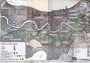 Color coded (by me) map showing the various alternative
and suggested routing for I-410 around the south of New Orleans
(Click on map for larger scale)
Normally there is some aerial photography of the intended
route. Unfortunately, the plans I had access to only had a badly
faded "blueprint of the middle section of the proposed I-410.
Not worth using in my opinion. Sorry.
Color coded (by me) map showing the various alternative
and suggested routing for I-410 around the south of New Orleans
(Click on map for larger scale)
Normally there is some aerial photography of the intended
route. Unfortunately, the plans I had access to only had a badly
faded "blueprint of the middle section of the proposed I-410.
Not worth using in my opinion. Sorry.
Page created on March 3, 2006
Questions and comments can be sent to Sandor
Gulyas
Return to the Louisiana Index Page